Watershed India Watershed India
Home
About
us
About
India
About Watershed
Management
Link Tool Box for Watershed
Management Our Partners
Our
Publications
Our
Achievements Free Tutorials
Useful
Sites
Photo Gallery
|
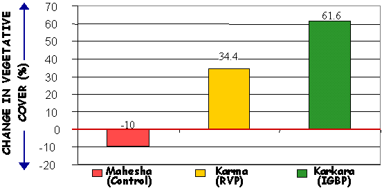
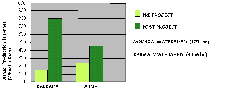
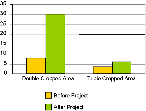
A comparative evaluation was carried out
by Land Use Consultants International (LUCI), New Delhi, to assess the impact and
sustainability of the IGBP Programme in RWS Karkara, Jharkhand, vis-a-vis watershed Karma
which was treated under the centrally sponsored River Valley Project (RVP) Scheme and
watershed Mahesha which was untreated and hence taken as the control watershed . The
following are some of the results of the evaluation.
Comparative change in vegetative cover :
Agricultural Production as a result of Rainwater Harvesting
Increase in Cropping Intensity due to Increased Water in Wells in
Karkara Village
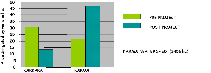
Ground water use as a result of rainwater harvesting
The Project developed in-house a
comprehensive set of 9 impact indicators for evaluation of watershed management
programmes. The 9 impact indicators are
| 1.Soil loss [topsoil
conservation]
2.Groundwater [groundwater
conservation]
3.Height-for-age [Health, wealth, gender parity, social
equity]
4.Consumer Durables [Wealth, Social
equity]
5.School Attendance [Education, Gender
parity]
6.Use and Maintenance [Sustainability,
Replicability]
7.Outsiders [Sustainability,
Replicability]
8.Replication
[Replicability]
9.Social Capital [Sustainability] |
31 Sediment
monitoring stations are equipped and operational throughout
the
country measuring the following parameters
3. Sediment Concentration
|
| Impact assessment of RWS
Burhanpura in terms of landuse changes and changes in vegetation density was carried out
using satellite remote sensing and GIS techniques in collaboration with the All India Soil
And Landuse Survey (AISLUS), Ministry of Agriculture, Government of India
RWS Burhanpura was treated under the Indo-German Bilateral
Project “Watershed Management”, where the Forest Department, Rajasthan was
responsible for the physical soil and water conservation activities like construction of
water harvesting structures, hydrological monitoring etc. especially on government lands
and the local NGO Kumarappa Institute of Gram Swaraj (KIGS) focused on sustainable
livelihood issues such as awareness raising, non-conventional energy, self-help promotion,
vocational training, horticulture,
etc..
Landuse/landcover classification and dynamics
The different classes of landuse/landcover in the RWS were : rainfed crop,
irrigated crop, plantation/miscellaneous trees, wasteland, open forest, closed forest and
water bodies.
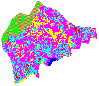
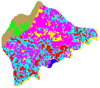
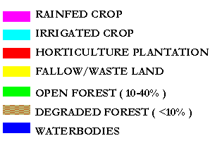
Fig : Landuse/Landcover of RWS Burhanpura for the periods 1995 and
2000
|
Rainfed agricultural area, fallow
land and open forests have decreased while irrigated agricultural area, plantation area
and degraded forests have increased. There
has been an overall improvement in the agricultural sector while the forests mostly on
public land have deteriorated from open to degraded category. Degradation of forest cover
may be due to unavailability of alternate energy sources, failure of monsoons for three
consecutive years or even felling and grazing.
Out of the total 547
ha of rainfed area (1995), 173 ha has converted to irrigated agriculture, 63 ha has
changed to plantation and 61 ha is currently fallow. This may be indicative of increase in
water availability, more judicious use of water and consequently more awareness amongst
farmers, betterment of economic conditions etc.
PRE-TREATMENT
PERIOD
POST-TREATMENT PERIOD
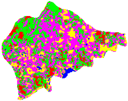
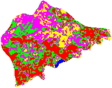
Fig : Vegetation Density Maps of RWS Burhanpura (1175 HA), Sikar District
Rajasthan (1175 ha), Sikar District Rajasthan for
the periods 1995 and 2000
There has been an overall increase in
the density of vegetation. Conversion of 4 ha very low, 45 ha low, 117 ha medium, 106 ha
high density classes to the very high density class have contributed to this increase of
224 ha to very high density.
|
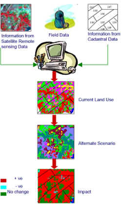
| Geo-Plan: A user friendly Decision Support System for Watershed Management was
developed in collaboration with the All India Soil and Land Use Survey (AISLUS), Ministry
of Agriculture, Government of India Satellite
remote sensing and GIS are high-end tools that can generate and store spatial and
non-spatial information and requires a certain level of technical expertise whereas
decision-makers have diverse field know-how. The project has developed a customized
Graphical User Interface (GUI) between the two so that once a comprehensive database is
fed into the DSS, decision makers can run models of "action plans" and weigh
alternatives before the final decision is made. Ideally a database should consist of
information on soils , current landuse slope, costs, yields, water requirements, land
ownership and infrastructure derived from satellite data, cadastral data, census data and
field data. The database is updated on a regular basis and analyzed for impacts during the
project as well as at the end of the project. Decision makers can then assess the impact
of their decisions and use this feedback to improve upon their planning for other
watersheds. GEO-PLAN has been developed in collaboration with the All India Soil and Land
Use Survey (AISLUS) Remote Sensing Centre, Noida (U.P.). The pilot study area is the
Representative Watershed Jaunla, Rajasthan

| Watershed
India Homepage | About Us | About India | About Watershed Management | Link Tool Box for Watershed Management | Our Partners | Our Publications | Our
Achievements
| Free Tutorials
| Useful Sites | Useful Sites | Photo Gallery |
 |
|
|
|